Discussion and Forecast:
For the Northeast and Mid-Atlantic States.
Issued: Sunday 11/23/08
The very cold and fairly active pattern of November (From Mid-month and on), will continue into much of December. All signs are very favorable for Below normal temperatures and near to slightly above normal Precip. At this time I'm thinking the coldest period of December is between the 1st and the 20th, then a gradual relaxation to slightly Below and Near normal temps towards the end of the month (Dec 20th-31st).
Overall Temps: will Average Below Avg: (-2.0 F to -5.0 F) for much of the M/A and NE.
Overall Precip: will Average Near to Slightly Above Normal:
Snowfall: For The NE will be Near Normal.
Snowfall: For The Mid-Atlantic States will Average Above Normal.
The Best chances for significant snow events will occur between the 8th-13th, and then again towards months end, between the 22nd and 28th. Overall I'm going with Clipper and CAA Advection systems to be the main reason for most of this activity and the continued cold pattern. A Miller B, or WAA Advection event is most likely between the 22nd and 28th, as a gradual pattern change begins to more normal levels and the NAO heads for more Neutral Index.
I'm quite confident and generally sticking with my ideas and thoughts from my winter forecast, which I've outlined as a cold and snowy month. A NEG to near Neutral NAO, and NEG AO signals as the key Teleconnections in this process. I've also alluded to a weakening Pacific Jet and near Neutral ENSO that would favor a Cold and active start to our Winter season in the East. So with this being said, and all key teleconnections being in place as we start the new month of December, it looks like a thumbs up and game on.
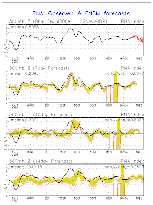
Here are some Key teleconnection Indices and Ensemble Forecasts, as we head into the month of December: All 3 are very favorable for a cold and active December in the East, especially the first half.
One thing is for sure, The cold air coming (Arctic) for the first half of December will be quite cold for many in the east, relative to normals. An onslot of arctic fronts and Clipper systems diving further south, will set the stages for snow chances into much of the M/A and even the SE and Tennessee Valley regions.
The suppression and plunge will really come between the 5th and near mid month.The thing to really watch IMO is towards the end of the month when I expect a relaxation of the Unseasonably Cold pattern. It's here, where a good storm could pop or major WAA advection type system advances from the Deep south or GOM into the M/A and NE. We'll see what happens, but I'm very confident December will bring and exciting time for many who enjoy winter events and Old man winters early grip.
The Teleconnections I've mentioned are Ideal for a Very Cold and Active pattern in the East. The ensemble forecasts and trends with all three of these teleconnections are the next best thing to perfect, and a combo We haven't seen here in quite some time.The NAO is really looking to go sustained NEG, and this will really help for possible Miller B coastal storms at anytime.
Take Care and most of all ENJOY IT !
Ruggie
The NAO:

THE AO:

THE PNA:

Links to my Winter Forecast:
My Blog and Site:
http://ruggieweather.blogspot.com/2008/09/my-2008-2009-winter-forecast.html
Easternuswx Thread:
http://www.easternuswx.com/bb/index.php?showtopic=175928
My November Call and pattern change to Cold: Looks good from October 30th.
http://www.easternuswx.com/bb/index.php?showtopic=178259&hl
Take Care,
Ruggie


2 comments:
i like your blog......
Thanks and enjoy !
Ruggie
Post a Comment