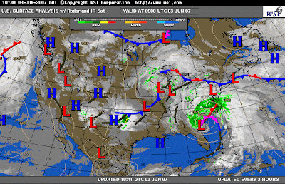
For total rainfall amounts, from Sunday through Monday PM.
Issued:
9:00 AM Sunday, June 3, 2007
As of Sunday morning my thoughts from yesterday's Post Stand. I continue to see a general 1.00" to 2.00" of total rainfall over most of the Delaware Valley. This includes all of NJ and DE, with the exception of NW NJ where 2.00" to 3.00" can be expected. I do however, see some areas west of PHL, from near BWI into Eastern PA, also receiving amounts of 2.00" to 3.00" before the system moves out tomorrow. The areas between the Delaware river and LNS, RDG, and ABE should see the highest rainfall amounts. Once again I'm forecasting (2.00" to 3.00") in some areas of The Delaware Valley, but still a general 1.50" to 2.50" can be expected in this Zoned area.
The remnants of TS Barry are now along the SC Coast. The leading edge of the rain shield is now moving into DE and the Chesapeake Bay region as of early this morning. This precip. Shield will continue to advance Northward, and overtake the Delaware Valley region throughout the day, from south to north. The heaviest of rain, should be over the region Tonight, then taper of during Monday morning as the storm pulls out of the region. The general track of this storm should be along the immediate coast or just inland as it approaches NJ and NY.
So in Summary:
1.00" to 2.00" of total rainfall can be expected through Monday PM, in these locations:
South and Central NJ
All of DE
Extreme SE PA including PHL.
1.50" to 2.50" in Eastern PA: between the Delaware River and LNS, RDG, and ABE including NW NJ. Extreme SE PA is the exception with 1.00" to 2.00" as mentioned.
Some of these areas in Eastern PA and NW NJ could see up to 3.00" in isolated spots.
Take Care,
Ruggie


No comments:
Post a Comment