


Nor'easter Likely Wednesday afternoon into Thursday morning !
My Call and thoughts for The Delaware Valley Region.
Let me start by saying this will be a moderate Nor'easter with some high winds, but this storm is not looking as strong or powerful as projected a few days ago. In addition, this storm will track further east and be about 300 miles off the DE and NJ coast Wednesday night, which will keep the strongest winds just offshore.
We can still expect very windy conditions with Northerly winds of 25-40 Mph and some gusts to 55 or 60 Mph along the NJ coast later Wednesday and Wednesday night. Further inland, Northerly winds of 15 to 30 Mph with gusts to 40 or 45 Mph will be more common.
With a more easterly track of 300 miles offshore, this will now place us in the coldest part of the storm's structure, and with it's strongest dynamics ! This will allow for more banding of heavier precip that will setup over the Delaware Valley Wednesday night. We should start as rain later Wednesday morning or early afternoon, but any rain will become mixed with snow/sleet, later in the day and into the early evening hours. Cold with highs on Wednesday only reaching the upper 30's. Many locations will see this mixed Rain/Snow and Sleet, change over too moderate to heavy wet snow later Wednesday evening and into the overnight hours.
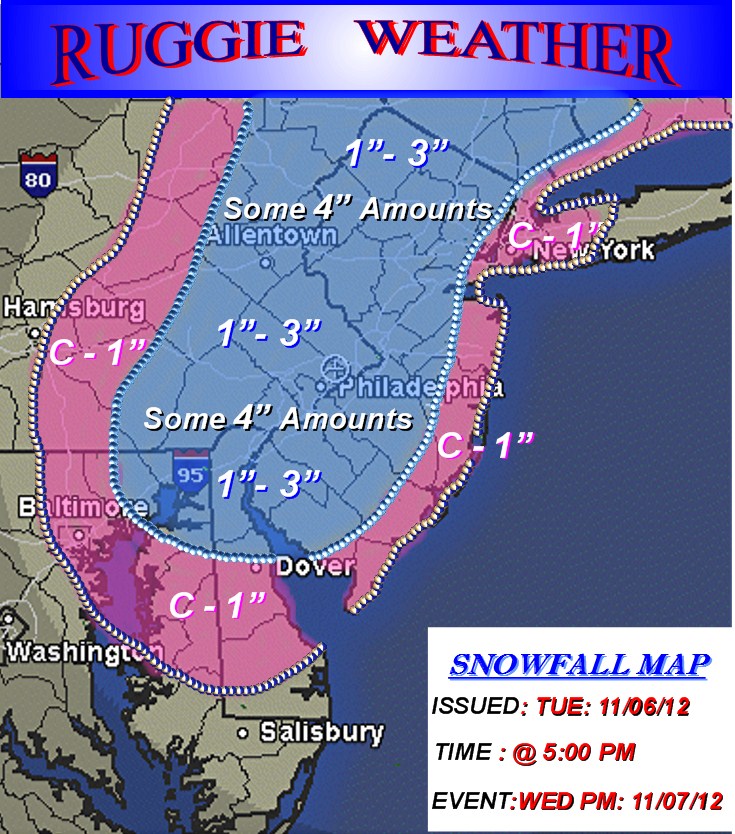
A quick 3-6 hour thump of moderate to heavy wet snow, is very possible where this banding sets up later tomorrow evening, and into the overnight hours. This could result in snow accumulations of 1"-3" over much of SE PA including PHL, Parts of Northern DE, and Interior Southern and Central NJ. This also includes the Lehigh Valley and Allentown area.
A few isolated spots could see up to 4" in the heaviest banding ! This storm will be very erratic in nature, and any snow accumulations will vary greatly over our region. So at this time, I'm setting the bar at a general 1"-3" and for a more widespread area. Temps will hold in the low to mid 30's during Wednesday night with Northerly winds at 15-25 Mph and gusts to 35 Mph in these areas.
Other areas towards the NJ coast and including Central and Southern DE could possibly see a light Coating to perhaps 1" of snow/sleet accumulations later Wednesday night. These area will likely see mostly rain and surface temps in the mid to upper 30's during tomorrow night. Only if precip falls moderate to heavy will coastal areas see a quick coating to perhaps 1" of snow accumulations.
If I see any changes needed on this tricky storm, I'll update tomorrow !
Take Care,
Ruggie
Here's my snowfall map !
No comments:
Post a Comment