


RUGGIE WEATHER:
By John Ruggiano
DATE ISSUED:
November 02, 2014
VALID:
From December 2014 Through February 2015 (Dec, Jan, Feb)
Another Cold Winter can be expected for the Central and Eastern CONUS. Expect higher snowfall amounts, and a more active storm track to shift further south and east this year !
A Weak El Nino Signal , along with a pronounced STJ (Subtropical Jet), will bring stormy conditions across much of the Southern US, and a good part of the Eastern 1/3rd of the Nation.
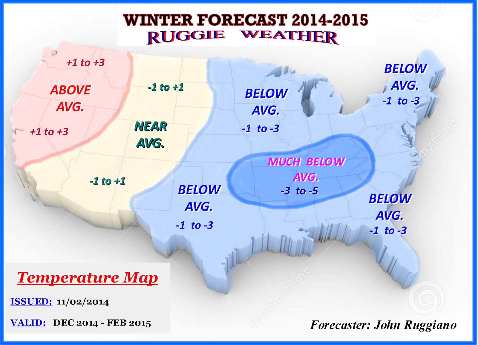
Another cold and snowy winter is on the way, but the coldest weather and most snowfall will occur further south and east this year compared to last year. The cold air will be delivered by another -EPO signal and -AO due to a blocking type pattern. Warm SST’s continue over the Northern Pacific and near AK. This continues to promote a -EPO and + PNA signal, which allows for more ridging over the Western CONUS, Western Canada and Alaska. Colder air is then forced SE and downstream into the Central and Eastern US, very similar to last year. This will continue for this upcoming winter, but not as harsh as last years brutal cold spells. (See Temperature Map)
With a weak El Nino (ENSO signal) expected for this year, a more active southern branch of the jet stream is likely. The Polar and Arctic Jet driven by a -EPO combined with the Southern Jet Stream driven by a weak El Nino, will produce a very active and stormy pattern for much of the Southern States, The Mid-Atlantic, and Northeast. Often We’ll see a Split Flow type pattern, Especially from Mid January into early March !
So this year things will change in comparison to last year, as the main storm track will likely be much further south, as weak El Nino conditions prevail. In addition, a more active subtropical jet can be expected. Last year we had a more pronounced Polar and Arctic jet, with a limited amount of activity from the Southern Branch. A strong -EPO and Pacific signal dominated for the most part, leaving the Midwest, Northern M/A and the NE in the Icebox with much above and record breaking snowfall.
The mean storm track for the 2014-2015 Winter Season will extend from the Southern Rockies, eastward to the SE States, and then mainly east of the Apps, through the M/A States and New England. Overrunning events will also be quite common from the Tenn/Ohio Valley into the Lower M/A States. This will also raise the flag for possible Moderate to Severe Ice Storms, from the Southern Plains, The Deep South and into parts of the SE. This is something to be aware of this winter season. I expect plenty of this from mid January into much of February.
Clipper type systems with the Polar Jet (P/J) and Arctic Jet (A/J) will be less common, than the last year. Sure, we’ll still have a fair amount of activity with the Northern branch, but most of the energy this year will come from the STJ and the effects of a weak El Nino, with more southern storm systems.
Some of these Southern systems will get a chance to phase with the Northern branch energy, so I expect several Miller A type storms, mainly in January and February ! With this setup, a Split Flow pattern will be more common during the mid and later part of Winter. (See Storm Track Map)
This year I'm forecasting "Above Normal Snowfall" to be concentrated from the Southern Rockies into the Southern Plains. The second area will be from parts of the Deep South, into the Tenn, and Lower Ohio Valley, much of The SE, all of the M/A States, and into New England.
All other areas will be "Near Normal Snowfall", with the exception of the NW PAC and The Northern Rockies, where I'm forecasting "Below Normal Snowfall". (See Snowfall Map)
The NAO (North Atlantic Oscillation) And other key Teleconnections.
The NAO/AO couplet that I mentioned in the past is starting to show up again from this past summer into the fall. I’m seeing very similar wavelengths, and I expect this couplet to continue into the fall and winter months. The overall trends are showing Neutral to Negative wavelengths, which suggest blocking is developing. Last year the NAO was more Positive and the AO neutral to negative thanks to the -EPO helping some. SST’s over the North Atlantic do suggest more of a NEG NAO developing for this upcoming winter. So when we do see the NAO going negative, storms from the Southern Branch or STJ, will likely move up and along the Eastern Seaboard !
My Winter Forecast for The Mid-Atlantic States (M/A) and Virginia !
The M/A and VA will see Below Normal Temps of (-1 to -3) and Above Normal Snowfall (125% to 175% of Normal Snowfall) for the 2014-2015 Winter Season !
Parts of Southern WV and the mountains of far SW VA, could see even colder temps of (-3 to -5) and Much Above Normal Snowfall (150% to 200 % of normal snowfall).
The winter season will start off slow with December being the mildest of the 3 winter months at near average temps and snowfall. Both January and February will be colder than normal with Above normal snowfall. February will be the coldest and snowiest month. As a bonus for snow fans, this could continue into early March before the pattern breaks down.
Here’s a breakdown for each month for the M/A Region, along with some forecasts for some selected areas.
December 2014
Temps: Near Avg. (-1 to +1)
Precip: Near Avg.
Snowfall: Near Normal
January 2015
Temps: Below Avg. (-1 to -3)
Precip: Above Avg.
Snowfall: Above Normal
February 2015
Temps: Below to Much Below Avg. (-2 to -5)
Precip: Above Avg.
Snowfall: Much Above Normal
My Forecast for Lynchburg, VA. (LYH)
Dec 01, 2014 - Feb 28, 2015 (Dec, Jan, Feb)
Mean Temperature: -2.0 F
(Below Avg.)
Mean Temp Range: -1.0 to -3.0 F
(Below Avg)
Total Snowfall Range: 22" to 30"
(Above Normal) Normal Snowfall is 17” for LYH VA.
Target Snowfall Prediction: 26"
Total Precipitation: Above Avg.
ROA (Roanoke, VA)
Temps: -1.0 to -3.0 F (Below Avg.)
Total Snowfall: 26" to 34" (Above Normal)
Overall Forecast: Temps: -2.5 F / Snowfall: 30"
CHO (Charlottesville, VA)
Temps: -1.0 to -3.0 F (Below Avg.)
Total Snowfall: 24" to 32" (Above Normal)
Overall Forecast: Temps: -2.0 F / Snowfall: 28"
RIC (Richmond, VA)
Temps: -1.0 to -3.0 F (Below Avg.)
Total Snowfall: 14" to 22" (Above Normal)
Overall Forecast: Temps: -1.5 F / Snowfall: 18"
DCA (Washington DC)
Temps: -1.0 to -3.0 F (Below Avg.)
Total Snowfall: 20" to 28" (Above Normal)
Overall Forecast: Temps: -2.0 F / Snowfall: 24"
BWI (Baltimore, MD)
Temps: -1.0 to -3.0 F (Below Avg.)
Total Snowfall: 24" to 32" (Above Normal)
Overall Forecast: Temps: -2.5 F / Snowfall: 27"
PHL (Philadelphia, PA)
Temps: -1.0 to -3.0 F (Below Avg.)
Total Snowfall: 28" to 34" (Above Normal)
Overall Forecast: Temps: -2.5 F / Snowfall: 31"
NYC (New York City, NY)
Temps: =1.0 to -3.0 F (Below Avg.)
Total Snowfall: 32" to 40" (Above Normal)
Overall Forecast: Temps: -2.0 F / Snowfall: 36"
MY GENERAL 2014-2015 WINTER OUTLOOK FOR THE CONUS:
In this segment I've attached all my maps, to summarize my overall Winter Outlook. Please see the (4) maps below: Temperature, Precipitation, Snowfall, and Overall Storm Track's. These maps best illustrate my outlook for the Months of: December, January, and February.
In this segment I've attached all my maps, to summarize my overall Winter Outlook. Please see the (4) maps below: Temperature, Precipitation, Snowfall, and Overall Storm Track's. These maps best illustrate my outlook for the Months of: December, January, and February.
These maps indicate the overall Anomalies for both "Temperatures" and "Precipitation" for the 3 month period.
In addition I have included a “Total Snowfall Map”, relative to normal and a “Mean Storm Tracks Map”, to show the type of pattern I‘m forecasting for the winter months.


Take Care,
Ruggie
Ruggie
1 comment:
You're welcome to enter NEWxSFC's 14th Annual 'Season-total' Snowfall Forecast contest.
Deadline 11:59 EST ... SUN ...30-NOV-14
---
TQ
http://www.newx-forecasts.com/
http://newxsfc.blogspot.com/
Post a Comment