1/23/10
Discussion for The Del Valley/NYC areas.
Yes I'm honking on this one guys and gals ! It's been quite a stretch of boring winter weather since our HECS on Dec 19th. January has been a big dud, as we've seen mainly a cold, but dry first half of the month, and a thaw with wetter conditions over the last 7-10 days.
So now we face a lake cutter for later this weekend: This occurs from Sunday afternoon into Monday morning, which will bring heavy rain, mild temperatures, and possibly a few thunderstorms. 1.00" to 2.00" of rain is likely with this storm, as the heaviest rain falls, from late Sunday night into early Monday AM.
Just ahead of the associated strong cold front, temps will rocket up to the mid 50's to near 60 on Monday. Behind this front, the winds increase to 15-30 mph and temps gradually tumble for Tuesday, back to near seasonable levels on Wednesday. This entire system at the surface and upper levels, sets the stages for a pattern change and snow threat for later next week.
The Polar jet is forced south during the week, as our stj continues to increase. The 2 jet streams begin to phase together in a favorable area, which sets up an overrunning scenario and southern storm to develop over the southern Rockies and the deep south towards mid week.
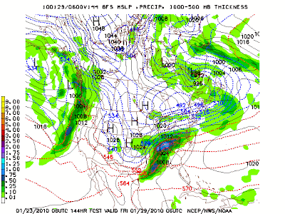
The Map Below: As we can see with H5 map for Wed Evening, we have a strong P/V near Hudson's Bay area with the northern stream, and strong s/w and energy diving into the Southern Rockies that's associated with the STJ. These 2 streams begin phasing together nicely.

As we head towards Thursday night our P/V shifts slowly east to a favorable position just north of New England. As you can see some great blocking and ridging begins setting up over Greenland and the North Atlantic, NAO going NEG. The energy with the stj and s/w phases in and is ejected east across the deep south. By this time a storm has developed over Texas and is heading towards the Deep south and Tenn Valley.


Precip in the form of snow, thanks to overrunning, has now spread into the M/A States by Thursday night and Friday morning.By Friday afternoon we have a nice wave of low pressure near the M/A coast and snow over the Northern M/A into SE NE. This looks to be a pretty nice snow event for PHL and NYC areas.This overall setup is looking very good and many models are continuing to show a similar scenario for Friday.

This event is 5-7 days out, but I'm thinking we could see a moderate snow event and get some snow in here before January closes out. If things pan out like I see them, we could be looking at a 3"-6" or even 4"-8" event for Friday or possibly Friday into Saturday. This will be something to watch and track during the week, so stay tuned and let's discuss the event here.
http://ruggieweather.phpbb3now.com/viewtopic.php?f=2&t=362
Take Care,
Ruggie


2 comments:
Ruggie,
Would the Baltimore area be looking at much snow with this next system you are talking about?
Yes BWI is in the game for the late week system. I think you guys are in my same thinking as PHL and NYC. A Moderate snow event is looking good.
Ruggie
Post a Comment